Around 5 pm Thur. afternoon, the National Hurricane Center (NHC) issued a new hurricane warning for parts of Louisiana coast ahead of Tropical Storm Barry’s expected landfall this weekend.
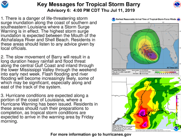
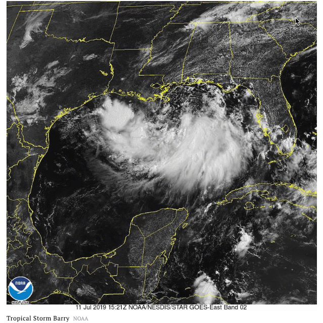
Barry transformed into a tropical storm earlier in the day on Thursday, is currently gaining momentum in the Gulf of Mexico about 85-90 miles south of the mouth of the Mississippi River, with sustained wind above 40 mph late Thursday evening. Hurricane models expected the tropical storm to traverse the northern Gulf of Mexico towards the Louisiana coast where it could make a direct hit as a Category 1 hurricane Friday night or Saturday between New Iberia and New Orleans.
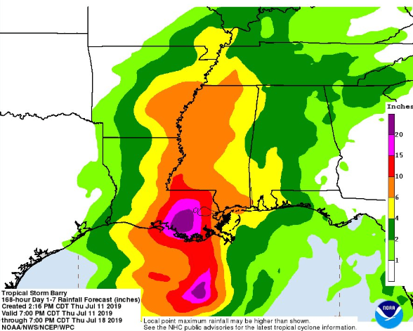
“Barry formed in the northern Gulf of Mexico Thursday and will continue to slowly move toward the central Gulf Coast into the weekend. Excessive wind shear has kept the system ragged and weak so far, but as atmospheric conditions improve into the weekend, the storm may take advantage of anomalously warm ocean waters and strengthen before making landfall in Louisiana. Rainfall and flooding will be the biggest risk with this system, with some data suggesting up to two feet of rain locally in southeastern Louisiana through the weekend,” said Ed Vallee, meteorologist and owner of Empire Weather LLC.
Rainfall and flooding will be the biggest threat to #Louisiana as #Barry approaches. 15-25″ of rainfall is possible in SE Louisiana including #BatonRouge and #NewOrleans pic.twitter.com/slUAzYcoSb
— Empire Weather LLC (@empirewx) July 11, 2019
The storm is moving to the west at 5 mph and has maximum sustained winds of 40 mph – will make a hard right hook towards landfall in the next 12 to 18 hours. The minimum central pressure is now 1003 MB…29.62 inches.
“Winds can be strong near where the system makes landfall which continues to be uncertain – most data suggests a landfall point along the central Louisiana coast, continuing northward into the Mississippi Delta. Wind speeds will depend on how much the storm can strengthen before landfall, but a strong tropical storm or category one hurricane with sustained wind of 70-80mph are possible. This can lead to damage to structures, downed limbs, and power outages,” Vallee said.
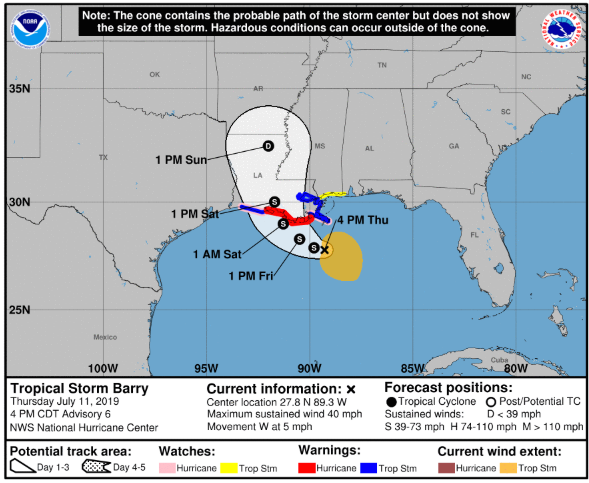
Vallee said weather models indicate the tropical storm could make landfall Saturday on the southeastern coast of Louisiana. He noted that Barry lacks the classic hurricane structure, but as it hooks right towards land on Friday – the storm could develop the traditional spin of a cyclonic storm.
WOFL Orlando meteorologist Jayme King – said “Barry is going to produce a tremendous amount of rain. So, there’s a lot of concern about flooding in New Orleans,” King added, “The French quarter is notorious for having awful drainage. The city is already saturated, and the Mississippi River is already high… We’re hoping they get through this okay.”
Whoa! The French Quarter is seeing significant flooding this morning. This was off Royal. @NWSNewOrleans
📷: Colin Crumbley pic.twitter.com/94UylJrNf2— Payton Malone (@paytonmalonewx) July 10, 2019
Biblical rains could undoubtedly be the biggest story of the weekend with total rain accumulations of 10 to 15 inches near and inland of the central Gulf Coast through the weekend.
New Orleans Mayor LaToya Cantrell told the Sun Sentinal that the upcoming storm would be an enormous test for the flood-control infrastructure built in New Orleans since 2005′s Hurricane Katrina. Local officials are concerned about the tropical storm making landfall with dangerously high water levels on the Mississippi River.
via ZeroHedge News https://ift.tt/2Y0kMWf Tyler Durden