“Brutally Cold Air Mass” Set To Unleash Snow Over Northeast Next Week
An Arctic blast of cold air is likely to roll into the Mid-Atlantic and Northeast regions this coming week, possibly producing one of the first snowmaking weather events of the year by late week.
“A very cold airmass for early November is poised to impact the Northeast late week into next weekend. A favorable upper atmospheric pattern should allow air from northern Canada to spill into the Great Lakes and Northeast. During this cold stretch, temperatures may average 10-20 degree F below normal for most of the Northeast, including the major cities. This may influence heating oil and natural gas demand, while allowing interior Northeast ski resorts to begin making snow for the winter season ahead, stated Ed Vallee, head meteorologist at Empire Weather LLC.
Vallee shared a Temperature Anomaly map that shows from November 03-10, temperatures across the Mid-Atlantic and Northeast could be significantly below trend, setting the scene for a possible snow event late next week.
Wow, a brutally cold air mass is set to be unleashed across the Northeast next weekend. Great snow making weather incoming! #natgas #energy #skinh #skivt pic.twitter.com/vbbihq9e5u
— Ed Vallee | Empire Weather LLC (@EdValleeWx) November 3, 2019
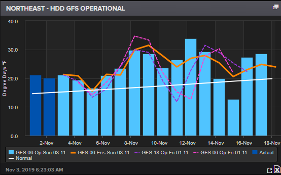
The Northeast heating degree day index prints above trend for the next 15 days, indicating natural gas and heating oil demand will likely move higher.
Vallee’s weather team at Empire Weather tweeted several posts suggesting a winter event is possibly headed to the Mid-Atlantic and Northeast late next week.
Cold risks. They’re back, they’re trending more significant, and they’re going to be impactful. How long will they last? Breaking it down in the AM energy report and updates throughout the day —> https://t.co/PE86blWthO #natgas pic.twitter.com/MhpEc5OI3B
— Empire Weather LLC (@empirewx) November 1, 2019
Snowmaking season is set to ramp up. Great looking pattern for New England ski resorts on the horizon in early November. Breaking down WHY in our latest reports! Sign up to work with us —> https://t.co/PE86blWthO #skivt #skinh pic.twitter.com/1cOMRAeFyV
— Empire Weather LLC (@empirewx) October 31, 2019
While the forecasts are still early, the exact timing and heaviest impacted regions are not yet known.
More developments will likely come early next week.
As November could begin with a major snow event in the Northeast, many are wondering what Old Man Winter has in store for North America. Weather reports from Reuters’ commodity desk suggest a “cold season” for many parts of Central and Northeast US.
“The North America winter outlook suggests a cold season across the central/northern US. If this scenario develops, it would point toward elevated winterkill risks for winter wheat, though deeper snow cover than normal could offset the risks. The US Plains in particular show the potential for a cold but wet winter, which might allow snow coverage to protect the Hard Red Winter (HRW) wheat crop, while drier conditions farther east may put the Soft Red Winter (SRW) wheat crop at higher winterkill risk.”
Figure 8: Composite precipitation anomalies (mm) from the top December-February analogs based on the leading ENSO forecast indicators (via Reuters)
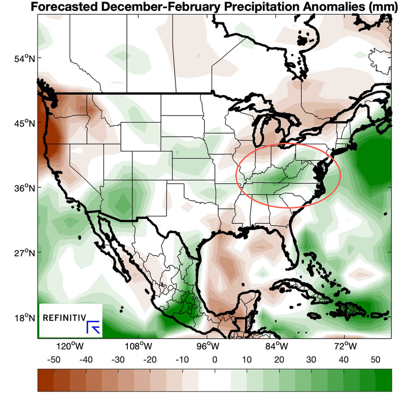
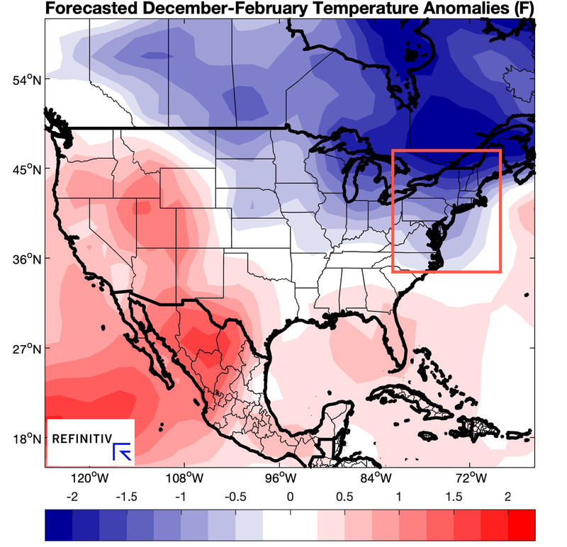
Figure 9: Composite temperature anomalies (°F) from the top December-February analogs based on the leading ENSO forecast indicators (via Reuters)
Winter is coming…
Tyler Durden
Sun, 11/03/2019 – 11:00
via ZeroHedge News https://ift.tt/2oLFbPo Tyler Durden