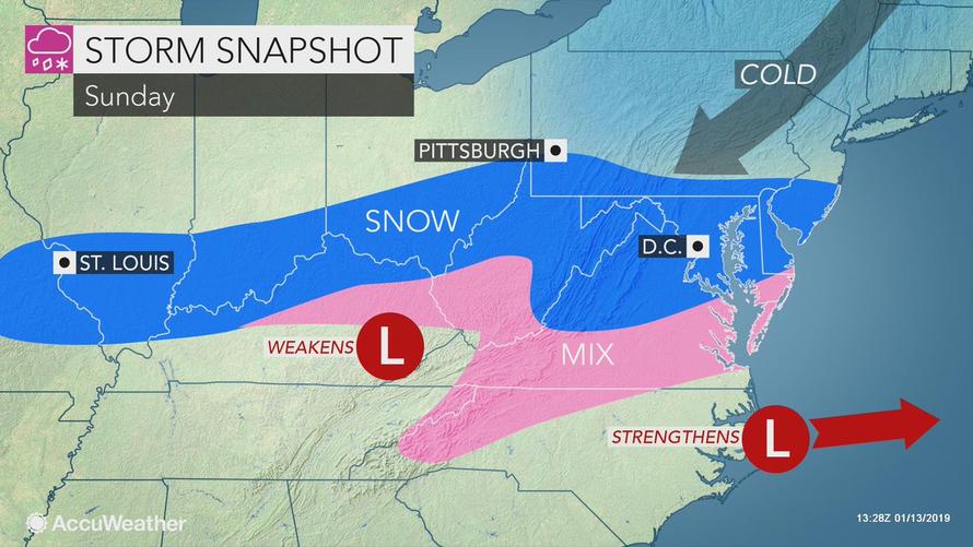
After what was a quiet but abnormally warm start to 2019, a severe winter storm has left seven people dead as it charged across the Midwestern US, striking the Mid-Atlantic coast on Sunday.
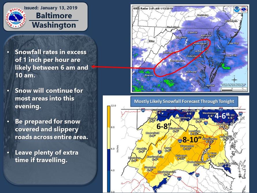
By late Saturday night, the storm had shifted over the Virginia, Washington, D.C., and Baltimore region, where 4 to 7 inches of snow is on the ground.
Weather models suggest the snow could get heavier around 2:30 p.m. for a few hours, especially in the Washington metropolitan area.
The Weather Prediction Center (WPC) warned that freezing rain would also be a big concern for the region into the overnight.
A winter storm will shift east off the Carolina coast through today. Heavy snow will continue over portions of the Mid-Atlantic while freezing rain is expected for the western Carolinas into southern Virginia. The snow and ice will contribute to slick travel into tonight. pic.twitter.com/7DPWMuaa5x
— NWS (@NWS) January 13, 2019
Virginia Gov. Ralph Northam declared a state of emergency on Saturday in anticipation of the storm.
“I am declaring a state of emergency in order to prepare and coordinate the Commonwealth’s response to anticipated winter storm impacts, including snow and ice accumulations, transportation issues, and power outages,” said Northam.
The state of emergency allows officials to “mobilize resources and to deploy people and equipment to assist in response and recovery efforts,” according to the press release.
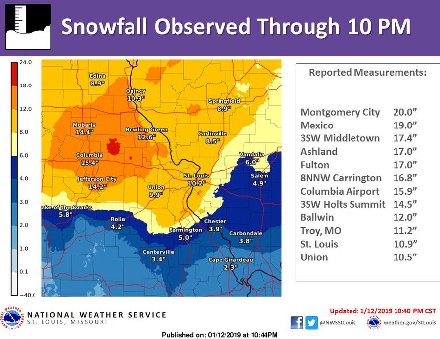
St. Louis, which was pounded the hardest by the storm so far, recorded almost 11 inches, forcing closures of Interstates 44, 64 and 70 around the city.
Parts of central Missouri, around Harrisburg, recorded almost 20 inches of snow.
Columbia, Missouri, saw more than one foot of snow, more than doubling a 109-year-old record for snowfall.
A Winter Storm Warning remains in effect for much of the Baltimore–Washington metropolitan area through 6 p.m. Sunday.
Vallee Weather Consulting meteorologist Ed Valle suggests that a “classic El Nino pattern” is developing, which combined with cold air, could mean additional storms for the East Coast into Feburary.
Valle made the point that natgas could be the greatest beneficiary of a significant cold pattern change coming to the East Coast in the second half of January into Feburary.
“The warm pattern much of the United States has been enduring to end December and start January is gradually changing now, and will continue to progress colder toward the end of January. We are seeing the beginnings of this change as a winter storm pushes through the Midwest, Ohio Valley, and Mid-Atlantic this weekend. This system has delivered locally up to 20 inches of snow in the St. Louis, MO metro area, and has already delivered up to 8 inches of snow in the DC metro area. As we push through the rest of January, a more classic “El Nino” pattern looks to develop, including a strong southern jet stream, which, combined with some cold, can likely bring additional winter storms to the Ohio Valley and East Coast into early February.
Another area impacted by this shift colder will be natural gas – after a strong start to the demand season, a bearish pattern with plenty of warmth has stifled early season cold, pushing natgas lower over the last 4-6 weeks. However, with this cold coming to end the month, we expect heating demand to continue to rise as populated areas of the southern Plains, Midwest, and East shift colder and stormier.”
Heating degree day (HDD), a measurement designed to quantify the demand for energy needed to heat a building, is already signaling that natgas demand is likely to increase in the lower 48 over the coming week.
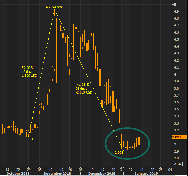
After a near -41% collapse in natgas from November’s 4.92 high, the current shift in cold and snowy weather is expected to blanket the East Coast in the coming weeks, could be a relieving sign for energy bulls.
Valle warns that another snowmaker for the East Coast is dead ahead.
East Coast Snow Lovers Rejoice! A very favorable pattern for snow and cold could potentially arrive next weekend and beyond…❄️❄️❄️ pic.twitter.com/AhEtmJzd19
— Ed Vallee | Vallee Wx Consulting (@EdValleeWx) January 12, 2019
Bigly winter storm signal next weekend on almost all data at this point. Suggest monitoring this system along and coast and interior – all areas in play right now. pic.twitter.com/ksF6RRjaO8
— Ed Vallee | Vallee Wx Consulting (@EdValleeWx) January 13, 2019
Ignore the specific numbers, but my goodness ensembles are suggesting quite the active period coming up. All 51 EPS members are shown below through 1/28… pic.twitter.com/rovzGOSKy1
— Ed Vallee | Vallee Wx Consulting (@EdValleeWx) January 13, 2019
via RSS http://bit.ly/2Fvhhxt Tyler Durden


