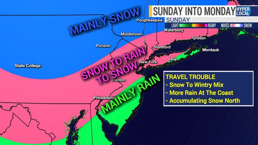
“Impactful Winter Storm” Could Blast Northeast Sunday Through Monday
For most of the week, we’ve been reporting on the chaotic weather situation affecting tens of millions of Americans before and during the Thanksgiving holiday season.
As many readers know, the Thanksgiving holiday week is one of the most traveled times of the year, and this year, it was hellacious for many traveling across Northern California and Oregon as a “bomb cyclone” detonated earlier in the week. By midweek, Central and Midwest states have been slammed by a powerful winter storm, that could end up in the Northeast by Sunday.
The latest developments of winter weather activity are from Arizona, Colorado, and Utah, where more than a foot of snow is expected to fall by late day. The winter storm is expected to move across the upper Midwest by late Friday.
A mix of wintery precipitation could turn into heavy snow for parts of Minnesota, Wisconsin, and Michigan by Friday evening.
Ed Vallee, head meteorologist at Empire Weather, said the next significant weather development could be a winter storm that moves across the Mid-Atlantic and Northeast on Sunday.
“An impactful winter storm will spread a myriad of precipitation types into the Mid-Atlantic and Northeast Sunday into Monday. Snow will be the dominant precipitation type in central New England where 6 or more inches of snow is possible. Closer to the major cities, snow will quickly change to a mix of precipitation Sunday afternoon and perhaps rain Sunday night, before transitioning back to snow possibly on Monday. There remains some uncertainty as to exactly where this storm will track, so the public is urged to frequently monitor forecasts into the weekend,” Vallee said.
New York City and other major Mid-Atlantic metros could see a wintry mix of precipitation on Sunday through Monday.
Vallee tweets that the upcoming winter storm could be one of the first significant snowmakers for the Northeast this year.
Good morning. It’s going to snow Sunday into Monday.
That is all.https://t.co/aLrrssI4QR pic.twitter.com/W7U8FT9H8K
— Ed Vallee | Empire Weather LLC (@EdValleeWx) November 29, 2019
He warned that holiday travelers returning home on Sunday could be greeted with dangerous road conditions along Interstate 95.
This may be a big problem Sunday afternoon if the European model holds true.
With low pressure passing off the S NJ coast, this is a cold look with icing a concern in E PA, NW NJ, and interior S. New England. pic.twitter.com/wq5TYnLxI4
— Ed Vallee | Empire Weather LLC (@EdValleeWx) November 29, 2019
Tyler Durden
Fri, 11/29/2019 – 11:43
via ZeroHedge News https://ift.tt/35W8cb9 Tyler Durden
