Coldest Air In Years Pours Into Parts Of US; Next Winter Storm Nears
Monday was an awful start to the workweek, with 15 million people under severe wind chill warnings across the northern Plains and Upper Midwest into the Northeast and New England.
For the Upper Midwest and Great Lakes, Monday was the coldest part of the week as temperatures are expected to rebound. For the Northeast, Tuesday is expected to be the coldest, and then temperatures will rebound through the end of the week.
The high today for New York City will be 22 degrees Fahrenheit and 12 degrees Fahrenheit in Boston (will be the coldest highs since 2019). The good news is temperatures will warm up after today, but there is colder weather ahead.
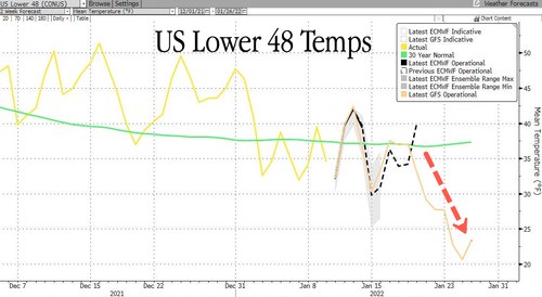
Weather models produced by Bloomberg show a massive cold blast could be ready to strike the US beginning next Wednesday (Jan. 19). Temperatures are forecasted to deviate significantly from a 30-year mean of around 37 degrees Fahrenheit to about 20 degrees Fahrenheit by Jan. 25.
Meteorologists at private weather forecasting firm BAMWX are saying, “medium-range data all in agreement for most persistent colder air of the season for the East ahead…winter storm potential increasing as well.”
Medium-range data all in agreement for most persistent colder air of the season for the East ahead…#winter storm potential increasing as well.
Why now vs previously?
Pac jet extension ahead (MJO 8) –> colder air being pulled down in the east #natgas #oott #energy $ng pic.twitter.com/JDInfNBDU3
— Kirk 📈 Hinz | BAM Weather (@Met_khinz) January 10, 2022
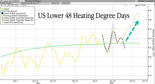
The rounds of cold spells across the country will increase heating demand through month-end.
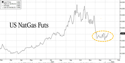
This may boost natural gas prices after a multi-month slump.
Winter has finally arrived.
Tyler Durden
Tue, 01/11/2022 – 10:53
via ZeroHedge News https://ift.tt/3qhi8c2 Tyler Durden


