‘Lee’ Set To Become “Major Hurricane” With ‘Possible New England And/Or Atlantic Canada’ Track
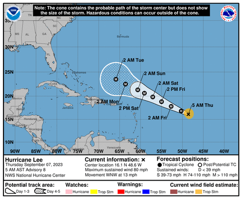
The National Hurricane Center warned Hurricane Lee is intensifying, and computer models suggest it might reach “major hurricane” status by early Friday.
Lee is located 965 miles from the northern Leeward Islands in open waters with maximum sustained winds of 80 mph. The Category 1 storm is moving west-northwest at 13 mph.
“The environment around the cyclone looks ideal for rapid intensification. The models are in fairly good agreement that significant strengthening should begin later today and continue into the weekend, when Lee will likely reach its peak intensity,” NHC said.
NHC warned, “Fluctuations in strength are likely from days 3 to 5 due to potential eyewall replacements, but Lee is still expected to be a dangerous hurricane over the southwestern Atlantic early next week.”
Computer models show Lee “slowing down before making a turn to the north in response to steering currents around it, particularly a dip in the jet stream moving toward the East Coast,” said Axios.
Late next week, it’s possible that Hurricane Lee tracks close to New England and/or Atlantic Canada.
The path out to sea may be blocked by a ridge of high pressure.
A long time to go, but I’d say the trend is not our friend with regard to land impacts
Tracking @ECMWFbot
pic.twitter.com/vNrZOhfSPQ
— Ben Noll (@BenNollWeather) September 7, 2023
Possible Cat. 5?
There is a chance that #Lee could be a Cat5 hurricane. We have one in the Pacific now called #Jova which has nearly doubled its wind speed in 24 hours.( 85 to 160mph). No threat to land with Jova. pic.twitter.com/knoCjsdF4c
— Jim Cantore (@JimCantore) September 7, 2023
Axios noted Lee is about “week to 10 days away from a potential threat to the U.S. mainland.”
Tyler Durden
Thu, 09/07/2023 – 09:40
via ZeroHedge News https://ift.tt/2C54FLf Tyler Durden

