Fast-Moving Clipper System To Blast Mid-Atlantic With Snow
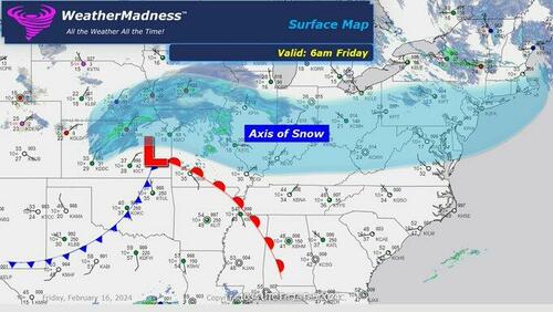
A fast-moving clipper system will dump snow across the Upper Midwest, North Central Appalachia, Mid-Atlantic, and parts of the Northeast on Friday into Presidents’ Day weekend.
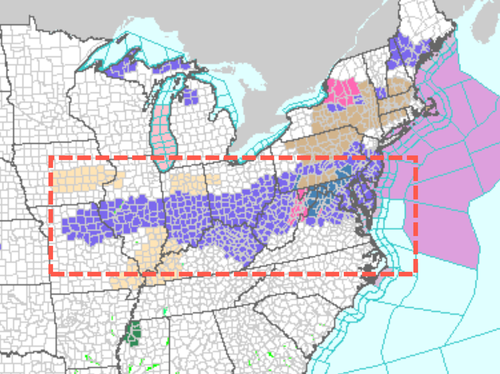
The National Weather Service issued winter weather alerts from Northwest Missouri to Baltimore, Maryland, Philadelphia, northeast New Jersey, and southeast New York.
“Here comes the next storm. Snow is already falling across the Midwest and Central Plains. 1-4 inches of snow is coming east through Saturday morning,” meteorologist Henry Margusity wrote on X.
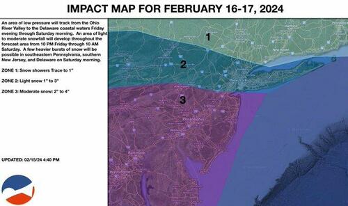
Private forecaster NY NJ PA Weather shared an impact map of the incoming snowstorm on X. The forecast states that the Washington–Baltimore metro area and the Philadelphia metro area, up to Trenton, NJ, are in “Zone 3,” which means 2” to 4” is expected. NYC is in “Zone 2,” with upwards of 3” expected.
Another storm for next week?
and then……. we turn our eyes on Feb 23rd timeframe pic.twitter.com/zPtpAos5pR
— NsfwWx ❄️ (@NsfwWx) February 16, 2024
Looking ahead, “Ensembles show exceptional warmth heading into March,” said Ryan Maue, a meteorologist and former NOAA chief scientist.
Ensembles show exceptional warmth heading into March
Weather Trader Thursday blog update: https://t.co/OiqnTWMMSf pic.twitter.com/77jLioVot1
— Ryan Maue (@RyanMaue) February 16, 2024
And this.
The most intense Atlantic hurricane remains Hurricane Allen from 1980 at 190 mph, which wouldn’t be Category 6 on the proposed scale (need 192 mph)
So, there is no need for Category 6 in Atlantic yet. https://t.co/NWvAF5nc7d
— Ryan Maue (@RyanMaue) February 15, 2024
The climate is always changing.
Tyler Durden
Fri, 02/16/2024 – 09:30
via ZeroHedge News https://ift.tt/v5EzKkS Tyler Durden


