Mid-Atlantic States Brace For Quick-Hitting Snowstorm
AccuWeather meteorologists report “a sneaky storm from the southern U.S. will swing northward and strengthen enough to blast part of the mid-Atlantic region with a dose of heavy snow” on Monday.
“It may be hard to believe that any snow is on the way, given the warmth and lack of wintry weather thus far this season,” AccuWeather Meteorologist Ryan Adamson said. Much of the Mid-Atlantic observed the 50s and 60s Fahrenheit over New Year’s holiday weekend, but that will all change come Monday.
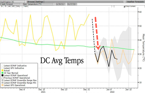
A cold blast will send Washington, D.C.’s average temperatures plunging 30-40 degrees Fahrenheit on Sunday night into Monday. Temperatures will be below a 30-year mean for the first half of the month.
The dramatic temperature shift will set up conditions for snow and ice in the mid-Atlantic region from Sunday night into Monday.
“As the storm strengthens and the precipitation moves northward into progressively colder air, rain will change over to snow in Baltimore and Washington, D.C., and snow may begin to fall in Philadelphia,” Ryan said.
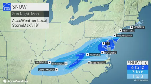
AccuWeather models forecast 6-12 inches from eastern Virginia to the eastern shore of Maryland, much of Delaware, and southern New Jersey.
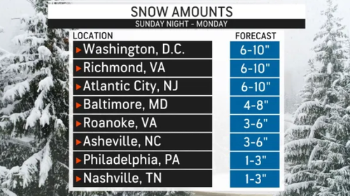
Philadelphia and New York City are on the storm’s northern edge with little or no accumulation expected. Here are snowfall forecast totals between Sunday night and Monday.
As for travel, the Capital Beltway around D.C. and the Interstate 95 from Richmond to Washington, D.C., to Baltimore to Philadelphia will probably be a mess tomorrow. As for air travel, staffing shortages and adverse weather conditions have produced massive amounts of cancellations every day since Christmas Eve.
Tyler Durden
Sun, 01/02/2022 – 17:35
via ZeroHedge News https://ift.tt/3FOw82t Tyler Durden


