Northeast Braces For Potential Bomb Cyclone As Next Winter Storm Fast Approaches
AccuWeather Senior Meteorologist Joe Lundberg delivered some unwelcoming news for millions of residents across the mid-Atlantic and Northeast on Thursday morning. He said a major snowstorm is expected to sweep across the region Thursday night into Friday, battering areas already hit with snow on Monday.
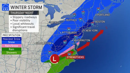
Lundberg said the storm could rapidly strengthen overnight and develop into a bomb cyclone. This means the storm’s central pressure will rapidly drop over 24 hours, indicating the storm will strengthen as it moves up the Northeast.
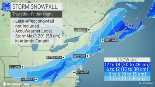
By Thursday evening, Kentucky, West Virginia, Maryland, Virginia, North Carolina, and Tennessee should experience accumulating snow. Around the Washington–Baltimore metropolitan area, where nearly a foot fell in some places, up to six inches of snow is expected through Friday. Philadelphia and New York City are expected to pick up around 6 inches. The heaviest snow could be across eastern Maine, Connecticut, Rhode Island, and eastern Massachusetts.
Expect slippery conditions along the Interstate 95 corridor from Washington, D.C. to Baltimore to Philadelphia to New York City to Boston.
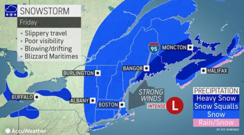
For Friday, expect a blizzard from eastern Maine across the border into New Brunswick, Canada. Conditions could quickly deteriorate if the storm undergoes bombogenesis.
For the working-age population working remotely, don’t expect a day off as there is no such thing as a snow day anymore. That also goes for students. Unless you can in sick for the “Omi-cold.”
Tyler Durden
Thu, 01/06/2022 – 14:00
via ZeroHedge News https://ift.tt/337DnUK Tyler Durden


