The Coming Collapse Of El Nino And Flip To La Nina
Authored by Arcfield Meteorologist Paul Dorian,
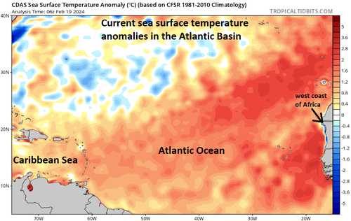
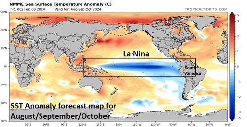
Above-normal sea surface temperatures continue this month across most of the equatorial part of the Pacific Ocean, but there are signs that this El Nino episode which began about a year ago will flip to La Nina conditions (colder-than-normal) by the early part of the 2024 summer season in the Northern Hemisphere. A flip from El Nino to La Nino across the equatorial Pacific Ocean can have big implications on the upcoming 2024 Atlantic Basin tropical season. In fact, this expected dramatic change in sea surface temperatures across the Pacific Ocean may be a major contributor to a very active tropical season in the Atlantic Basin as atmospheric conditions are typically more favorable (lower wind shear) during La Nina episodes for the development and intensification of tropical storms. A second favorable factor for a very active tropical season in the Atlantic Basin is the likely continuation there of widespread warmer-than-normal sea surface temperatures. Finally, as oceanic cycles play a critical role in global temperatures, a flip from El Nino to La Nina in the world’s largest ocean could mean a return to closer-to-normal levels following a spike during the past year or so.
Details
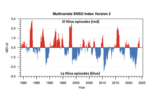
A transition from El Nino to ENSO-neutral is likely by spring 2024 and odds are increasing for a full-blown moderate-to-strong La Nina by the time we get to the summer season in the Northern Hemisphere which coincides with the first part of the Atlantic Basin (includes Atlantic Ocean, Caribbean Sea, Gulf of Mexico) tropical season. This El Nino event began about a year ago following back-to-back-to-back years in which La Nina dominated the scene in the equatorial Pacific Ocean. For the past several years, most El Nino events have been rather short-lived lasting on average about 12-18 months whereas La Nina occurrences have usually lasted for a considerably longer periods of time.
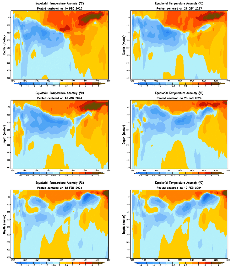
While sea surface temperatures are currently at above-normal levels in the tropical Pacific Ocean, there are changes lurking just beneath the surface…literally. Water temperatures from the surface level to about 50 meters down are still above-normal as we approach the middle of February; however, the departures from normal have lessened noticeably in recent weeks. In addition, colder-than-normal water has gradually risen closer to the surface in recent weeks. Also, low-level winds were near average over the equatorial Pacific in recent weeks while upper-level wind anomalies were generally easterly over the east-central Pacific. Convection (i.e., thunderstorm activity) remained slightly enhanced in the central Pacific and close to average in areas to the west of there. Collectively, this coupled ocean-atmosphere system reflects an El Nino in an overall weakening phase.
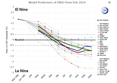
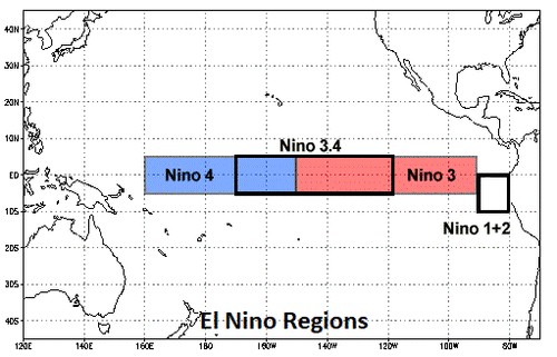
In addition to oceanic and atmospheric observational reasons to support the idea of a change in the near-term, numerous computer forecast models indicate a transition to “ENSO-neutral” during the spring 2024 and then to La Nina during summer 2024. Specifically, temperatures in the “El Nino 3.4” region (central part of the equatorial Pacific Ocean) are predicted to drop in most computer forecast models from the current 1.5-2.0°C higher-than-normal levels to near neutral during the spring season, and then down to 1.0 °C or so below-normal by the early part of the summer season.
In terms of impact on weather, El Nino has indeed contributed to a stormy winter season across California with numerous powerful ocean storms moving from the Pacific Ocean into the western part of the US and this unsettled pattern is likely to continue at least for the next few weeks. This enhanced storm activity in California is rather typical of an El Nino winter season with plenty of rain in low-lying sections and snow in the higher elevations. (By the way, what was not typical was the La Nina winter season of 2022-2023 in which California was pounded by numerous storms resulting in high rainfall amounts in low-lying sections and record snowfall in the higher elevations of the Sierra Nevada Mountains).
In terms of an impact on the upcoming 2024 Atlantic Basin tropical season, La Nina conditions in the Pacific Ocean can be a critical contributing factor to what I fear could be a very active year in the Atlantic Ocean, Caribbean Sea, and Gulf of Mexico. In general, La Nina summer seasons feature lower wind shear levels across the breeding grounds of the Atlantic Ocean and this reduction is more favorable for the development and intensification of tropical storms (shear defined as change of wind speed and direction with height).
In addition to the favorable aspect for tropical activity helped along by La Nina conditions in the Pacific, the breeding grounds of the tropical Atlantic Ocean are currently featuring much warmer-than-normal sea surface temperatures and this pattern is likely to continue right into the summer (tropical) season. Warmer-than-normal sea surface temperatures in the Atlantic Basin is favorable for tropical storm development and intensification. One final note on the potential impact of La Nina, oceanic cycles are critical in terms of global temperature patterns; especially, when dealing with the world’s largest (Pacific) ocean. There has been a spike in global temperatures since the formation of this latest El Nino about a year ago and, if indeed, La Nina forms and is sustained – as is likely – then global temperatures are likely to return to much closer-to-normal levels.
* * *
More from Meteorologist Paul Dorian…
Tyler Durden
Thu, 02/22/2024 – 06:30
via ZeroHedge News https://ift.tt/Ydr9TUS Tyler Durden
