Get ready for round two of crazy weather in California
Another Pacific storm is expected to strike California on Wednesday afternoon, bringing a threat of mudslides to the area of the most destructive wildfire in state history and a blizzard warning in the Sierra Nevada.
The Butte County Sheriff’s Office issued a flood evacuation warning Tuesday for Pulga, a small town northeast of Paradise. The notice read: “if you are in this area, you should evacuate to higher ground.”
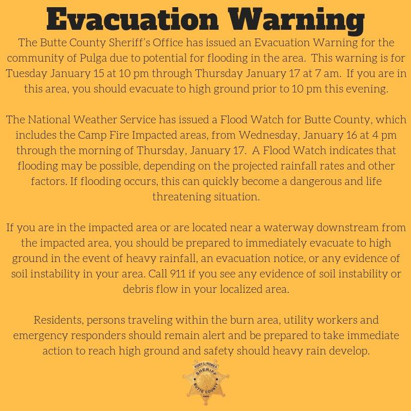
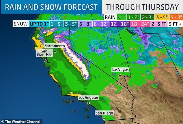
Most of Butte County area was included in a flood watch by the National Weather Service (NWS), which warns of 3 inches of rain in the valley and up to 6 inches in the foothills between Wednesday and Thursday.
Unlike the storm from earlier this week, this new round of rain is slow and steady, forecasters said, which could trigger mudslides.
“If flooding occurs, this can quickly become a dangerous and life-threatening situation,” the Butte County Sheriff’s Office warned.
A series of storm systems will bring very heavy rain to lower elevations of California and some surrounding states. Areal flooding and flash flooding, including burn scar mud and debris flow, will be possible through Thursday. pic.twitter.com/QlKIoKDrSc
— NWS (@NWS) January 16, 2019
This could be the strongest storm of the year with torrential downpours triggering flash floods in the San Francisco Bay Area.
Flood and high wind watches were posted for the Sacramento area, with NWS warning of widespread power outages, downed trees, and difficult driving conditions.
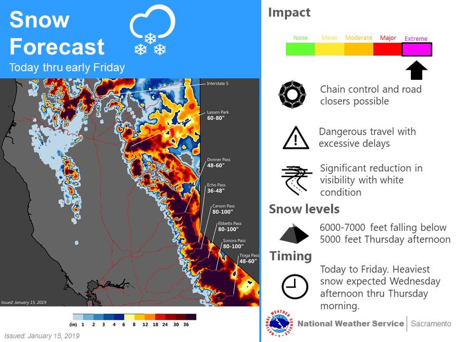
The storm is expected to bring blizzard conditions to the higher elevations of the Sierra Nevada through Thursday, with meteorologists predicting as much of five feet of snow in higher elevations and wind gusts of up to 100 mph on ridgetops.

Intense snow is also expected for the mountains in Northern California and north into the Cascades.
A week of storms has left officials worried about the potential danger for thousands of people living in foothill and canyon areas devastated by last year’s wildfires.
Rainfall records could be broken in areas such as San Jose and Riverside, where 1.42 inches and 1.37 inches of rain are expected, respectively, according to NWS.
The rain should subside by Thursday afternoon, said Bonnie Bartling, a weather specialist with the NWS in Oxnard.
“This one is going to be a little bit different,” Bartling said.
“We’re going to tap into subtropical moisture, which means we’re going to have some decent rainfall and gusty winds off and on.”
The same storm system is expected to hit the Midwest, Mid-Atlantic, and the North East later this week into the weekend, fueled by arctic air from a polar vortex.
“A strong storm has impacted California over the past few days, leading to nearly 2 inches of rainfall in Los Angeles and feet of snow across the Sierra Nevada.
This same system will traverse the United States through the weekend, bringing impactful along the I-80 and I-70 corridors Friday across the Mid-Continent, then deliver a major winter storm to portions of the Northeast. While specifics are still to be determined, the signal for a large, impactful storm along the East Coast is quite strong,” said Vallee Weather Consulting meteorologist Ed Valle.
People who live in the Mid-Atlantic and or the North East now is the time to prepare for the second round of winter weather that could rear its ugly head this weekend.
via RSS http://bit.ly/2AOykHu Tyler Durden