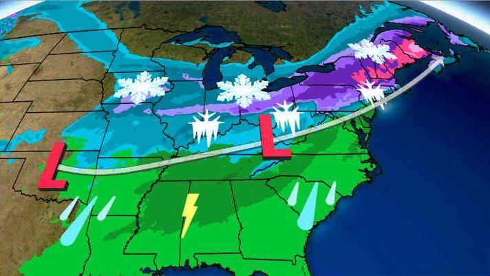
A series of winter storms traversing the country will bring significant snow and ice to the Midwest and Northeast this weekend followed by an ice storm that could paralyze travelers.
Approximately 100 million people are currently under a winter storm watch, warning or advisory across the US.

Travel has already been disrupted, with 500 flights canceled as of Friday morning, according to FlightAware.com.
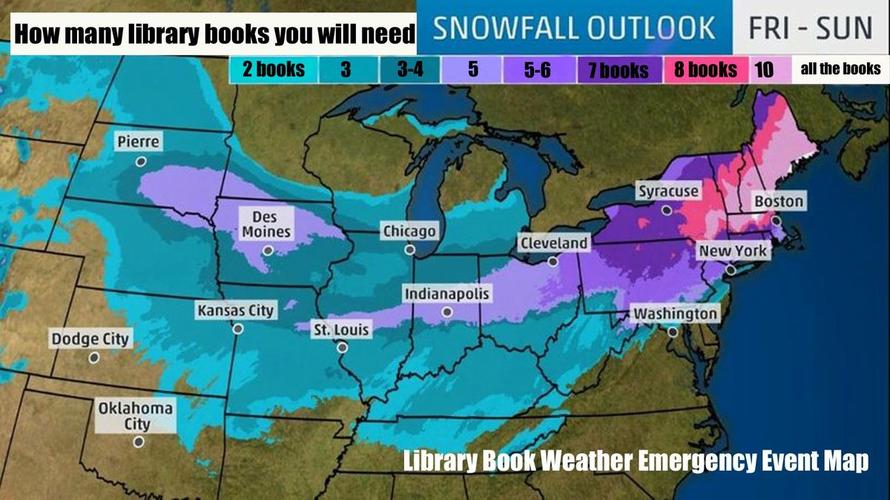
Vallee Weather Consulting meteorologist Ed Valle warns of heavy snow, with blizzard-like conditions, could leave parts of the northern Mid-Atlantic and Northeast with a “plethora of precipitation,” specifically, several feet of snow in parts of the interior Northeast.
“A strong storm will move into the Northeast over the coming days, delivering a plethora of precipitation types and hazards. Snow will be the main precipitation type from northern Pennsylvania into northern New England with 1 to 2 feet of snowfall expected. Amounts of 30-36” locally are possible in the mountains of Vermont, New Hampshire and Maine – perfect conditions ahead of a long holiday weekend at ski resorts. Heaviest snow is expected from Saturday evening through Sunday morning is these regions. Further south, a nasty mix of precipitation types is expected from south-central PA into central and southern New England including Harrisburg, Pa., Allentown, Pa., Hartford, Ct., and Boston, Ma. Here, snow will be the initial hazard, transitioning to an icy mix of sleet and freezing rain overnight Saturday.
A modest accumulation of snow (4-8”) along with locally 0.25-0.50” icing is expected. Closer the coast, snow Saturday evening will change to rain overnight from Philadelphia to New York City, but not before a few inches of accumulation. As colder air rushes back in Sunday afternoon, a flash freeze is expected as temperatures tumble into the single digits above and below zero Sunday night. This will lead to any slush and standing water freezing quickly on roads and sidewalks. Brutally cold air will impact the entire Northeast Monday,” Vallee reported.

The latest weather models are indicating that the snow is expected to start Saturday evening in Boston and New York, which will then turn into a wintry mix into Sunday. New York could warm up enough for rain Sunday morning, but a flash freeze is likely in the afternoon. Boston could get about 6 inches of snow, with much more to the north and ice to the south.

Most of the coastal cities could see rain, but a few miles inland it will be freezing rain and then mostly snow in the interior. Winter storm watches have already been posted for upstate and inland New England. Heavy snow and sleet could exceed over one foot. The Interstate 95 corridor through New England could be the epicenter of the ice storm, with up to an inch of freezing rain possible in Connecticut, Rhode Island, and Massachusetts.
Following the storms, arctic air will pour into the country as far south as Florida, leaving most of the continental US with below-average temperatures.
via RSS http://bit.ly/2VZNYc8 Tyler Durden