A dangerous heat wave is expected to hit much of the United States this weekend – stretching from the Plains and Midwest all the ay to the East Coast, according to the Weather Channel.
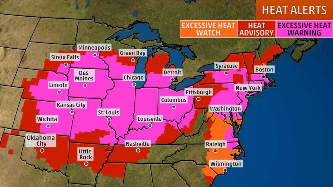
The National Weather Service has issued excessive heat warnings, watches and heat advisories in the Plains, Midwest and much of the East to warn residents of the dangerously hot conditions over the next few days.
Excessive heat warnings are issued when afternoon heat indices are expected to be dangerous, if not deadly, for those with prolonged exposure to the heat. Overnight temperatures may not drop far enough to bring relief from the heat, particularly in larger cities, which tend to “hold in” heat more than rural areas. –Weather Channel
As Dagny Taggart details, via The Organic Prepper blog:
AccuWeather estimates that more than 87 million Americans live in an area where a daily record-high temperature could be set on Saturday, and says more than 200 million in the eastern two-thirds of the nation will swelter in very hot and humid conditions into this weekend.
Here’s what you need to know about this heat wave.
As of the time of this writing, the National Weather Service’s latest update (which is valid through Sunday, July 21) stated the following:
…A dangerous heat wave is building in the central and eastern U.S…. …Severe weather and flash flooding are both possible for the Upper Midwest this evening… An upper-level ridge is building over the southeastern U.S., setting the stage for what will be a miserably hot and humid weekend for millions of Americans.
The sprawling area of high pressure will drive hot and humid air north and east from the Gulf through the Northeast. Daytime temperatures will soar into and through the 90s from the Plains eastward, and overnight minimums in the 70s and 80s will provide little relief. Heat Advisories, Excessive Heat Watches, and Excessive Heat Warnings are in effect for the Plains, Mississippi and Ohio Valleys, and the Eastern Seaboard.
Dozens of record high minimum temperatures are forecast to be set across the eastern U.S., and a handful of record high maximum temperatures will be challenged. The heatwave is expected to persist through the weekend across the east, but a cold front ushering in cooler air will march across the U.S. as an upper-level trough begins to build near Hudson Bay.
Scattered thunderstorms are expected along fronts moving through the north-central U.S., a few of which could be severe and produce heavy rainfall. Slight Risks of both severe weather and excessive rainfall are in place this evening for parts of the Great Lakes region, with more storms possible across the Upper Midwest tomorrow. (source)
Our advice? Stay indoors and keep cool…

Taggart offers more a bit more valuable advice:
Here’s how to stay safe in extremely hot weather.
Until temperatures cool down a bit, strenuous physical exercise and manual labor should be avoided or limited if possible. At least try to avoid them during the hottest part of the day. Frequent breaks from the heat are also highly recommended.
Drink plenty of water and avoid alcohol, especially while outdoors or in places that do not have air conditioning. Seek shelter in cool places.
Check on young children and the elderly frequently, as they are at heightened risk of heat-related illness.
Avoid walking pets and barefoot on paved and concrete areas during the late morning and afternoon hours as these surfaces can become hot enough to cause severe burns to paws and feet.
Do not leave children, elderly or disabled people, or pets in cars – even for a few minutes (and even if the windows are open). According to the National Weather Service,
Meanwhile, thunderstorms are expected throughout the Midwest, which Taggart notes: “could be devasting for the region – and our food supply.”
via ZeroHedge News https://ift.tt/2Z3h4bE Tyler Durden