New Yorkers Prepare For Roller Coaster Ride Of Temperatures This Week
October is coming in red hot. New York City could reach record-setting temperatures on Wednesday before much cooler temperatures arrive later in the week, Refinitiv data showed.
From Tuesday through early Wednesday, weather models show that the average daily two month temperatures (Fahrenheit) in NYC could be anywhere from 6 to 12 degrees above normal.
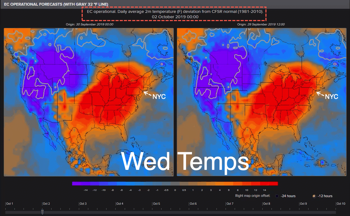
The mercury is expected to reach 90 degrees by Wednesday, could tie a record last set in 1927. If 91 to 92 degrees is recorded in Central Park on Wednesday, it would be the 5th time in 150-years.

The heat is being driven by a high-pressure ridge across the eastern U.S., part of a see-saw effect that’s also seeing a winter storm and frigid cold race across the west, Bloomberg noted.
New York Metro Weather LLC details how “cold Canadian air” will rush into NYC on Thursday.
Cold air is expected to swoop in on Thursday, could keep high temperatures in the 63-70 degree range through mid-month.
Tim Morrin, a meterologist with US National Weather Service in Upton, New York, told Bloomberg that New Yorkers could feel temperatures drop as much as 20 degrees on Thursday.
“It will be a real roller coaster as we go through the week,” Morrin said.
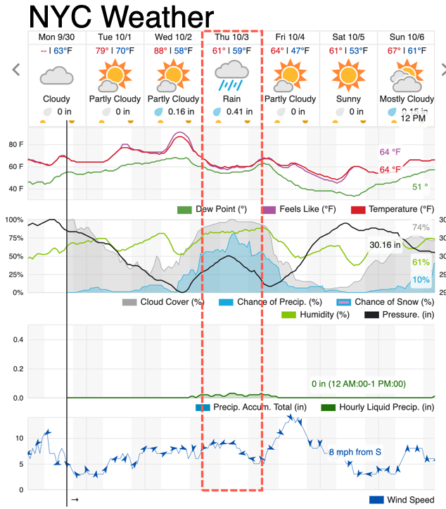
Here’s a closer look at NYC temperatures for the week:
Monday
Mostly cloudy, with a high near 67. East wind 8 to 14 mph.
Monday Night
Mostly cloudy, with a low around 61. Southeast wind 6 to 9 mph.
Tuesday
Mostly cloudy, with a high near 75. Southwest wind 5 to 11 mph.
Tuesday Night
A chance of showers between 9 pm and 3 am. Partly cloudy, with a low around 67. Southwest wind 11 to 13 mph. Chance of precipitation is 30%
.Wednesday
A slight chance of showers between 1 pm and 3 pm, then a chance of showers and thunderstorms after 3 pm. Mostly sunny, with a high near 89. Southwest wind around 11 mph becoming northwest in the afternoon. Chance of precipitation is 30%.
Wednesday Night
A 40 percent chance of showers. Mostly cloudy, with a low around 61.
Thursday
Rain likely, mainly before 1 pm. Mostly cloudy, with a high near 67. Chance of precipitation is 60%.
Thursday Night
A 50 percent chance of rain before 5 am. Mostly cloudy, with a low around 56.
Friday
Mostly sunny, with a high near 67. Breezy.
Friday Night
Mostly clear, with a low around 48. Breezy.
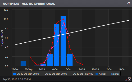
New Yorkers might have to switch their thermostats onto heat later this week and through the weekend. This is shown in the heating degree day (HDD) chart for the Northeast below:
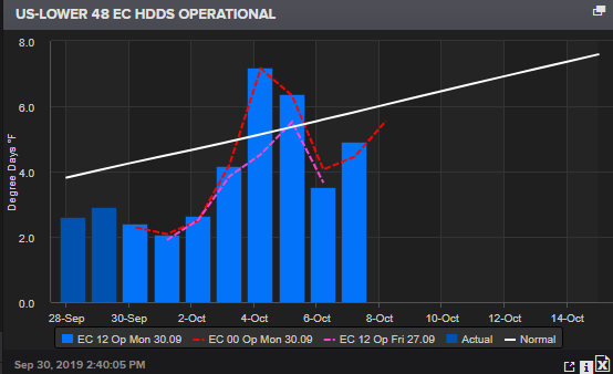
As for the rest of the contiguous US, HDD will be above the trend line later this week, indicating that millions more will be heating their homes across the country.
A 45-day HDD Northeast chart shows that millions of people in Connecticut, Delaware, Maine, Massachusetts, Maryland, New Hampshire, New Jersey, New York, Pennsylvania, Rhode Island, and Vermont, will likely switch their thermostats onto heat through month-end.
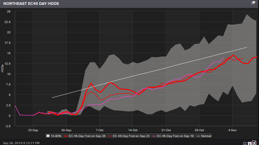
HDD that is above trend, or at least just a spike, could indicate that natgas demand is about to surge.
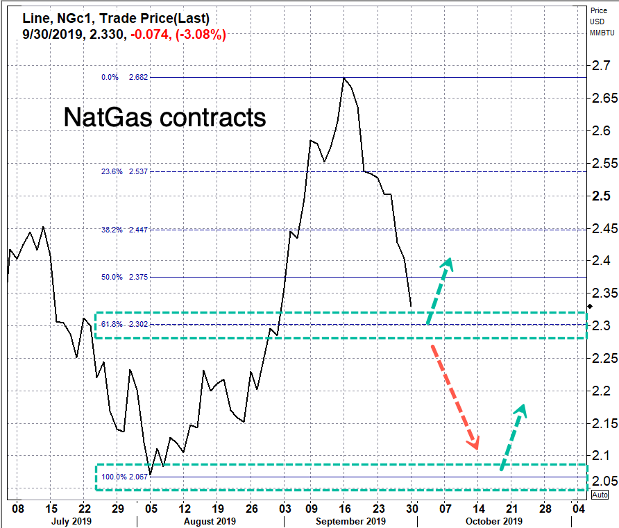
While the storage outlook for the natural gas market is still very bearish, the possibility of a natgas demand surge, due to colder weather, could prop up future contracts of Henry Hub Natural Gas in the 2.30 range, or 61.8%-Fib. If 2.30 fails as support, a re-test of 2.067, or August low would likely be imminent.
* * *
Maybe a fitting weather song for New Yorkers this week…
Tyler Durden
Mon, 09/30/2019 – 16:46
via ZeroHedge News https://ift.tt/2nfZ2FB Tyler Durden