Visualizing The Power And Frequency Of Earthquakes
Tyler Durden
Thu, 06/04/2020 – 21:05
The surface of our planet is in a constant state of creation and destruction as the plates of the Earth collide. It is this movement of the Earth’s crust that causes earthquakes, sending tremors throughout the world.
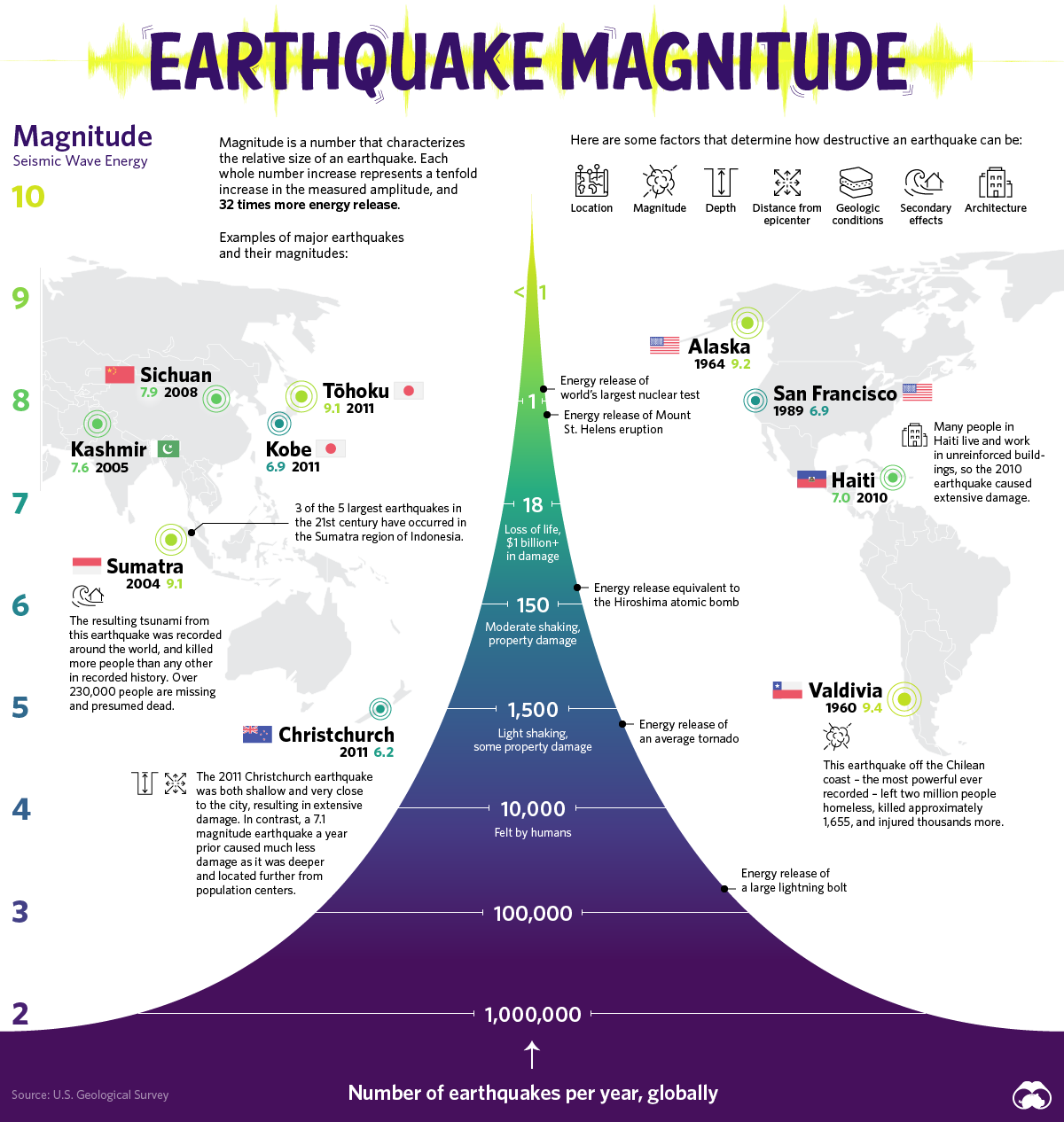
Today’s graphic by Visual Capitalist is inspired by a classic USGS diagram that tracks the scale and frequency of earthquakes.
Shifting Foundations
Earthquakes occur because the crust of the Earth is made up of several plates. The boundaries of these plates create faults that can run into one another.
Earthquakes describe both the mechanism that causes a sudden stress release along plate boundaries and also the ensuing ground shaking.
They occur when stress builds up along a tectonic fault. This stress causes the two surfaces of the fault, which had previously been stuck together due to friction, to suddenly move, or slide, releasing energy in the form of seismic waves.
Measuring an Earthquake’s Impact
There are three factors to assess the impact of Earthquakes – magnitude, energy, and intensity.
Magnitude is a number most commonly associated with the Richter scale, describing the size of an Earthquake on a scale from 0 to 10 – the latter of which is the maximum motion recorded by a seismograph. Each increase by one on the scale represents a tenfold increase in the amplitude. There are over a million tremors around the planet each year, but it’s not until an earthquake reaches a magnitude of 4 that humans can typically feel it.
Another way to measure the size of an earthquake is by how much energy it releases. The amount of energy radiated by an earthquake is a measure of the potential for damage to man-made structures.
An earthquake releases energy at various frequencies, and in order to calculate accurately, you have to include all frequencies of shaking for the entire event. Some research suggests technology could harness this energy for power generation.
Intensity describes the severity of an earthquake with a qualitative evaluation of its effects on the Earth’s surface and on the built environment. An earthquake may have a high magnitude but if a city or landscape experiences little damage, it can be said that the intensity is low. The Modified Mercalli Intensity Scale measures this intensity.
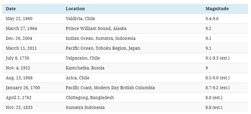
The World’s Largest Earthquakes by Magnitude
Prior to the development and use of seismographs, around 1900, scientists could only estimate magnitudes, based on historical reports of the extent and severity of damage.
Earthquakes are a fact of life on Earth and mark distinct moments in history. One would think given our knowledge of earthquakes, that humans would avoid these locations – however, the very faults of the Earth also create its greatest advantages.
Living with Your Faults
It’s extremely common to find human settlements along the fault lines where earthquakes occur most frequently. Some could say that this is because these decisions were made before a complete understanding of science enabled us to know the potential risks involved.
However, a recent scientific study reveals that there may be more to the pattern than previously thought. Tectonically active plates may have produced greater biodiversity, more food, and water for our human predecessors.
Certain landscape features formed by tectonic processes such as cliffs, river gorges, and sedimentary valleys create environments that support access to drinking water, shelter, and an abundant food supply.
This inherent problem reveals that humans are more connected to their environments than previously thought. It comes down to a question of how well humans can adapt their lifestyle and built environments to a dynamic planet.
Now let’s worry about the asteroids…
via ZeroHedge News https://ift.tt/2XZUpOl Tyler Durden