Cross-Country Winter Storm Could Pummel California, Northern Plains, And Possibly Northeast
The Weather Prediction Center of the National Weather Service wrote in a short-term forecast that a “major storm system” will “spread heavy snow in the mountains” of California and the West through the weekend. The storm will then unleash a blizzard across the Northern Plains and could leave parts of the Northeast with wintry weather later next week.
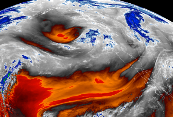
A satellite image of the storm arriving on the West Coast.
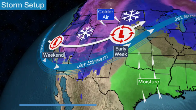
Here’s more on WPC’s forecast this weekend for the Northwest:
“A deepening trough aloft and frontal system at the surface moving through the West will continue to spread heavy snow in the mountains, a wintry mix for inland valleys, and heavy coastal rain across the region this weekend.
“An impressive stream of moisture from the Pacific associated with an atmospheric river will help to promote both high rainfall and snowfall rates as well as totals.
“The impacts will be widespread from north to south with numerous winter weather-related advisories in effect. Starting across the Pacific Northwest, Northern Rockies, Great Basin, and California, snowfall totals through the weekend will generally range between 12-24 inches, locally higher, for higher elevations in the mountains. The heaviest snowfall is expected for the Sierra Nevada with several feet forecast.”
Storm setup for this weekend.
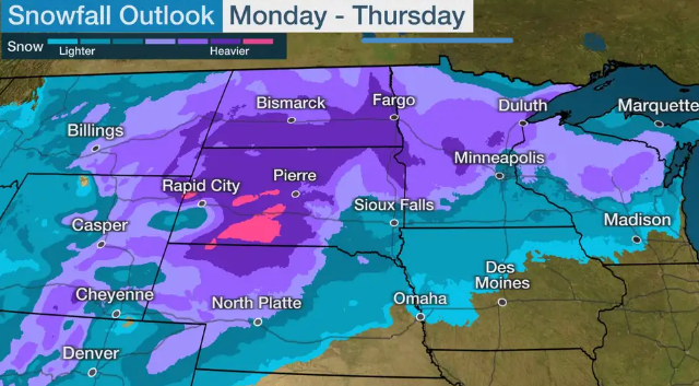
After this weekend, the storm will traverse parts of the Northern Plains by Monday. Later in the evening and into the overnight through Tuesday, heavy snow and high winds could produce blizzard conditions in parts of eastern Montana, eastern Wyoming, western Nebraska, the Dakotas, and Minnesota.
By late Tuesday into Wednesday, the snow-producing system will arrive in parts of Wisconsin and northern Michigan.
The Weather Channel’s computer modeling shows Northern Plains has the highest percentage of accumulating snow.
“We are increasingly confident that we will be dealing with a pretty significant Northern Plains blizzard next week,” Greg Carbin, chief of forecast operations for the Weather Prediction Center, told NYTimes.
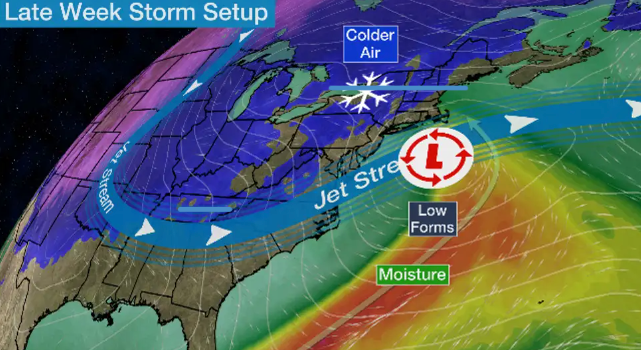
Later in the week, the system pushes towards the East Coast. The Weather Channel explains the forecast then becomes complicated:
First, we expect a couple of early-week cold fronts to deliver at least some cold air to the East ahead of this storm.
That’s important because as moisture from the storm begins to override that cold air, some snow, sleet or freezing rain could break out in parts of the East as soon as late Wednesday or Thursday.
After that, low pressure is expected to form near or off the East Coast Thursday. Where that low tracks will play a large role in how much, if any, snow the Northeast may pick up late next week, and where it would fall.
The possibilities range from a low tracking so far out to sea there’s little or no additional precipitation anywhere in the Northeast, to a track just offshore but with enough cold air to wring out at least some snow closer to the coast, to a track along the coast or inland with snow mainly in the interior Northeast but rain at least for a time near the coast.
Severe weather for the Northern Pacific and Plains appears to be guaranteed at this point, but later next week, forecasts for the Northeast are still uncertain. This could be the first winter storm of the season to have coast-to-coast impacts.
Tyler Durden
Sat, 12/10/2022 – 12:00
via ZeroHedge News https://ift.tt/Lyeuf2s Tyler Durden