‘Pipe-Bursting’ Cold Blast Headed For Northeast
Authored by Meteorologist Paul Dorian of Arcfield Weather,
Overview
Punxsutawney Phil will make his annual prediction on the prospects for an early spring this Thursday, February 2nd, and my guess is that he will see his shadow indicating six more weeks of winter. At least, that is what I would recommend to my fellow Pennsylvania prognosticator. There are processes unfolding in the upper part of the atmosphere over the polar region of the northern hemisphere that suggest there may very well be additional cold air outbreaks for much of the nation as we head through February and into March. In fact, a brutally cold air mass is headed to the Northeast US for Friday into Saturday with zero degrees on the table in New York City.
One part of the country that may not be vulnerable to cold air outbreaks in coming weeks is the Southeast US and, in particular, the state of Florida where a persistent upper-level ridge may keep it warm right into spring training season. In addition to the prospects for more cold, the overall weather pattern should remain quite active as well across the nation with numerous rain/snow/ice events on the way. Even the state of California – which has experienced a break in the action for the past ten days or so – will see a stormier pattern return to the region in early February; especially, the northern half.
Background
The month of January is likely headed to a finish that will result in it turning out to be the 2nd or 3rd warmest on a nationwide basis compared to any in the last 40 years. This unusually warm month of January has been quite a contrast to December which featured some bitter cold air masses across the nation including one that arrived in the Mid-Atlantic region just in time for the Christmas Eve/Christmas weekend. Each of these past two months has been quite active with multiple storm systems impacting many parts of the country. In particular, the state of California was pummeled by ocean storms in the period from late December to around the third week of January. Looking ahead, one change in the upper atmosphere over the polar region of the Northern hemisphere suggests that cold air outbreaks can continue for much of the nation into February and the active weather pattern is likely to continue with multiple storms on the horizon bringing more rain, ice or snow.

The “stratospheric warming” phenomenon
One way to monitor the potential for wintertime Arctic air outbreaks into the central and eastern US is to track the temperature pattern in the stratosphere over the polar region of the Northern Hemisphere. The stratosphere is the second major layer of the atmosphere just above the troposphere and below the mesosphere. It occupies the region of atmosphere from about 12 to 50 km, although its lower boundary tends to be higher nearer the equator and lower nearer the poles. The stratosphere defines a layer in which temperatures rise with increasing altitude. At the top of the stratosphere, the thin air may attain temperatures close to 0°C. This rise in temperature is caused by the absorption of ultraviolet (UV) radiation from the sun by the ozone layer. Such a temperature profile creates very stable atmospheric conditions and the stratosphere lacks the air turbulence that is so prevalent in the troposphere. Consequently, the stratosphere is almost completely free of clouds or other forms of weather.
Sudden stratospheric warmings (SSWs) are among the most impressive dynamical events in the physical climate system. During the winter months in the polar stratosphere, temperatures are typically at or below minus 70°C. The cold temperatures are combined with strong westerly winds that form the southern boundary of the stratospheric polar vortex which plays a major role in determining how much Arctic air spills southward toward the mid-latitudes. This dominant structure is sometimes disrupted in some winters by being displaced, split apart or even reversed. Under these circumstances, the winds can decrease or change directions and the temperatures in the lower stratosphere can rise by more than 50°C in just a few days.

In response to the stratospheric warming (and associated layer expansion) at the high latitudes, the troposphere cools down dramatically (with layer contraction) at the high latitudes and pressure rises. This tropospheric cold air can then be more easily transported from the high latitudes to the middle latitudes given the “high-latitude blocking” that often sets up over places like Greenland and northeastern Canada. The entire process from the initial warming of the stratospheric at high latitudes to the cooling in the troposphere at middle latitudes can take several weeks to unfold. [For more information on the stratospheric warming phenomenon visit our “Meteorology 101” page for an extended video discussion on the topic].
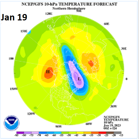
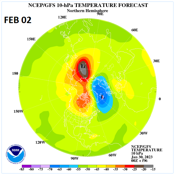
Current stratospheric warming event
During the middle part of January, the polar vortex normally positioned near or over the North Pole began to get “stretched out” and two separate warming areas began to show up aloft. By the last week of January, a significant area of warming developed at stratospheric levels over the Siberia region of the Northern Hemisphere and the polar vortex was displaced a bit away from its prior location. By the early part of February, this area of warming is expected to rotate to a position centered right near the North Pole and the polar vortex will become displaced and shrunk in size compared to the way it looked a few weeks ago. This stratospheric warming event is likely to result in the displacement of cold air masses from the high latitudes into the middle latitudes during February and perhaps even into March – delaying the start of spring in much of the nation. The one exception to this outlook may be the Southeast US and, in particular, the state of Florida which may enjoy warm weather from now right into the spring training season thanks in large part to the stubborn high pressure ridge aloft in that part of North America.
Active pattern to continue with rain, ice and snow
In addition to the prospects for more cold air outbreaks across much of the nation, the overall weather pattern is likely to remain quite active in coming weeks. Upper-level high pressure ridging is likely to remain centered over the southwestern Atlantic/Southeast US – typical of La Nina winters – and this will present a natural temperature gradient with colder-than-normal air to be centered over the central US. This “battleground” region in between the ridge (mild) to the south and east and the upper-level low (cold) to the north and west has been and will continue to be a conduit for the movement of low pressure systems to move from the south-central states to the Northeast US. Out west, California has experienced a break in the action during the last ten days or so, but a stormier pattern is likely to return to the Golden State beginning early in February; especially, the northern half.
Let’s wait and see what Phil has to say.
* * *
Tyler Durden
Tue, 01/31/2023 – 14:05
via ZeroHedge News https://ift.tt/KWuPM2S Tyler Durden