Alaska Pounded By Superstorm, May Unleash Worst Flooding In 50-Years
Residents on Alaska’s western coast braced for dangerous weather as the remnants of Typhoon Merbok traversed the Bering Sea region. The storm hit late Friday night and will last through the weekend.
“Latest models show coastal surge higher than the November 2011 storm that brought significant flooding to the area,” the National Weather Service (NWS) said, adding that flooding could be “potentially historical.”
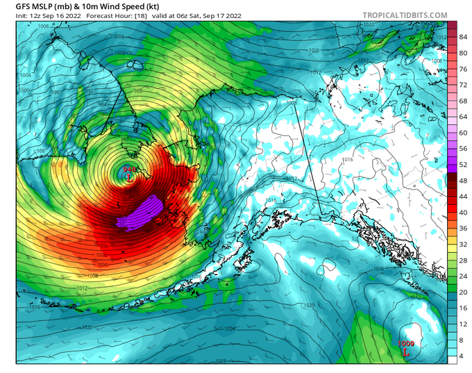
“This is a dangerous storm that will produce widespread coastal flooding south of the Bering strait with water levels above those seen in nearly 50 years,” NWS warned.
This storm is so big it will take about 3 hours for the sun to fully set on it. pic.twitter.com/uZCZ3Lxu0j
— NWS Alaska Region (@NWSAlaska) September 17, 2022
NWS office in Fairbanks said the storm “may exceed the 2011 Bering Sea Superstorm.” The weather agency tweeted an area where severe coastal flooding will occur through the weekend.

NWS meteorologist Alan Shriver, based in Anchorage, told NBC News that the storm has “derived its energy from the warm sea surface,” calling it “an exceptionally rare event.”
Shriver tweeted waves in the south central Bering Sea exceed 50 feet — making it extremely dangerous for any vessel transiting the region.
Updated weather and wave observations from NOAA buoy 46035, located in the south central bering Sea 275 miles (450km) west of St. Paul Island. Max significant wave height was 51.8 ft (15.8 m). #akwx @Climatologist49 pic.twitter.com/lDWPmKlrFI
— Rick Thoman (@AlaskaWx) September 16, 2022
Along with coastal flooding, wind gusts between 50-75 mph are expected and could reach as high as 100 mph along the upper west coast of the state and in the Aleutian Islands, Mike Youman, lead meteorologist at AccuWeather, said.
“There hasn’t been a September storm this strong in the northern Bering Sea region in the past 70 years,” tweeted Rick Thoman, a climate specialist with the Alaska Center for Climate Assessment and Policy.
On Saturday morning, there were reports of wind and flooding damage across the Bering and coastal regions of Alaska’s western coast.
Reports of wind damage and flooding continue to come in tonight from across the Bering and coastal W. Alaska. This is just the beginning. We will continue to see strong winds into Saturday and flooding from an extreme storm surge all the way up the west coast.#akwx pic.twitter.com/5oxBfryiR8
— Melissa Frey (@MelissaDFrey) September 17, 2022
For reference, my village has an elevation of 26 feet above sea level.
The electric utility (AVEC) has fuel tanks tipping over in the wind, boats floating away, & evacuated relatives saying they had to wade through waist deep water. Cousins with water literally to doorsteps. pic.twitter.com/Yid53hg2bb
— Angutekaraq (@AlaskaGirl74) September 17, 2022
“Worst storm I’ve ever had.” -Judy Bunyon, Hooper Bay.
Homes off foundations, power lines down, and roads under water.
This was the scene in Hooper Bay tonight from Paul Galvez/Lower Yukon S.D. Since this video was taken, winds have increased & water levels continue to rise. pic.twitter.com/WpwJIumhjL— Melissa Frey (@MelissaDFrey) September 17, 2022
Tyler Durden
Sat, 09/17/2022 – 11:00
via ZeroHedge News https://ift.tt/3TvD9CB Tyler Durden