Robot Dives 1.5 Miles, Maps French Shipwreck With 86,000 Images And Recovers Artifacts
Authored by Neetika Walter via Interesting Engineering,
A remotely operated robot has retrieved artifacts from a 16th-century shipwreck more than 1.5 miles beneath the Mediterranean, offering a glimpse into how precision deep-sea robotics is transforming underwater exploration. Guided from a support vessel above, the system used camera-fed navigation and robotic pincers to maneuver across fragile debris fields, capture high-resolution imagery, and recover centuries-old objects without disturbing the surrounding site.
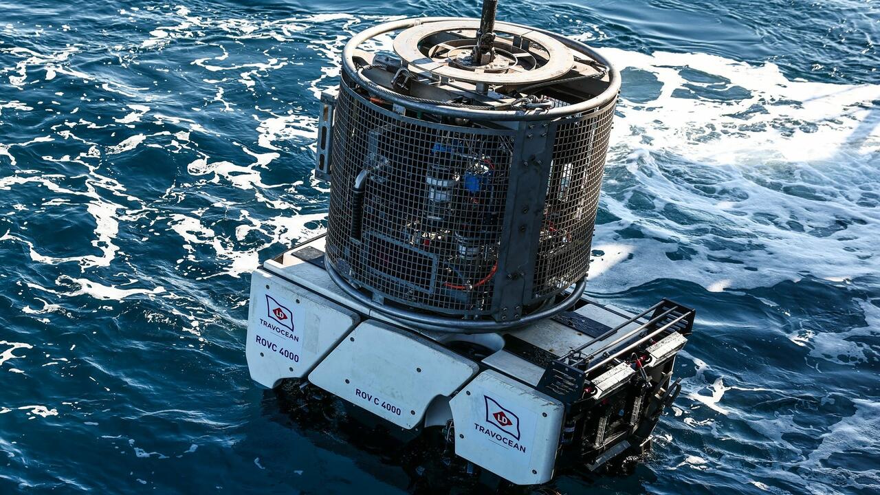
The mission, led by the French Navy and underwater archaeologists, centers on a wreck known as Camarat 4, discovered during a routine seabed survey. The site lies at extreme depth, where pressure, darkness, and limited access make human intervention impossible.
Operators control the robot through a tethered system, watching live video feeds as it descends for nearly an hour before reaching the seafloor. Once in position, the robot scans the wreck, hovering carefully over scattered cargo and structural remains.
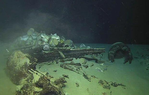
According to the CBS News, the vehicle captures thousands of images while navigating tight spaces, helping researchers document the site without physically disturbing it.
At depths exceeding 1.5 miles, the robot operates under extreme pressure of nearly 150 atmospheres, where conventional equipment would fail. Its reinforced structure, stable tether system, and precision controls allow it to function reliably in near-freezing, low-light conditions.
Precision at extreme depth
“You have to be extremely precise so as not to damage the site, so as not to stir up sediment,” a French navy officer said.
That precision is critical. At such depths, even minor disturbances can obscure visibility and damage artifacts that have remained intact for centuries. The robot’s manipulators are designed to operate with minimal force, allowing it to lift fragile objects like ceramic jugs without breakage.
The system also records up to eight images per second, generating tens of thousands of visuals during a single mission. These images are later used to construct detailed 3D models of the wreck, enabling researchers to study it remotely.
“The visibility is excellent. You almost can’t tell it’s so deep,” archaeologist Franca Cibecchini said, highlighting the clarity achieved during the operation.
Mapping the unseen world
The wreck is believed to be a merchant vessel that once carried ceramics and metal cargo across Mediterranean trade routes. Archaeologists say such discoveries are rare, particularly at this depth.
“We don’t have very detailed texts about merchant ships in the 16th century, so this is a valuable source of information on maritime history,” lead archaeologist Marine Sadania said.
In addition to historical insights, the mission showcases how robotics is expanding the boundaries of exploration. The robot’s ability to revisit the site, capture data, and retrieve objects with minimal disruption marks a shift toward non-invasive underwater archaeology.
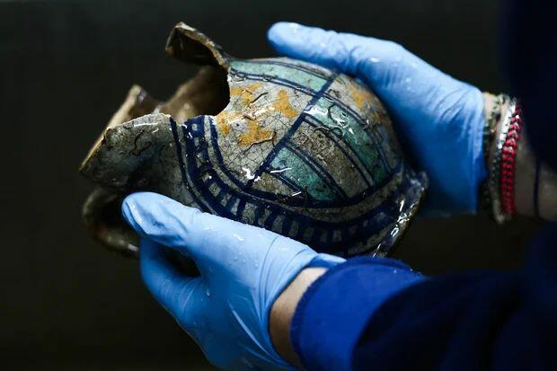
“It’s one of the deepest objects ever recovered from a wreck in France,” Sadania told AFP, referring to one of the ceramic finds brought to the surface.
As deep-sea robotics continues to evolve, such systems are expected to play a larger role not only in archaeology but also in subsea inspection, resource mapping, and environmental monitoring.
Tyler Durden
Fri, 05/01/2026 – 13:20
via ZeroHedge News https://ift.tt/9WKyEd6 Tyler Durden